
DC Metro Map (2026): All 6 Lines + Printable PDF
Every Metrorail line and all 98 stations on one diagram, free to download and print.
The DC Metro map
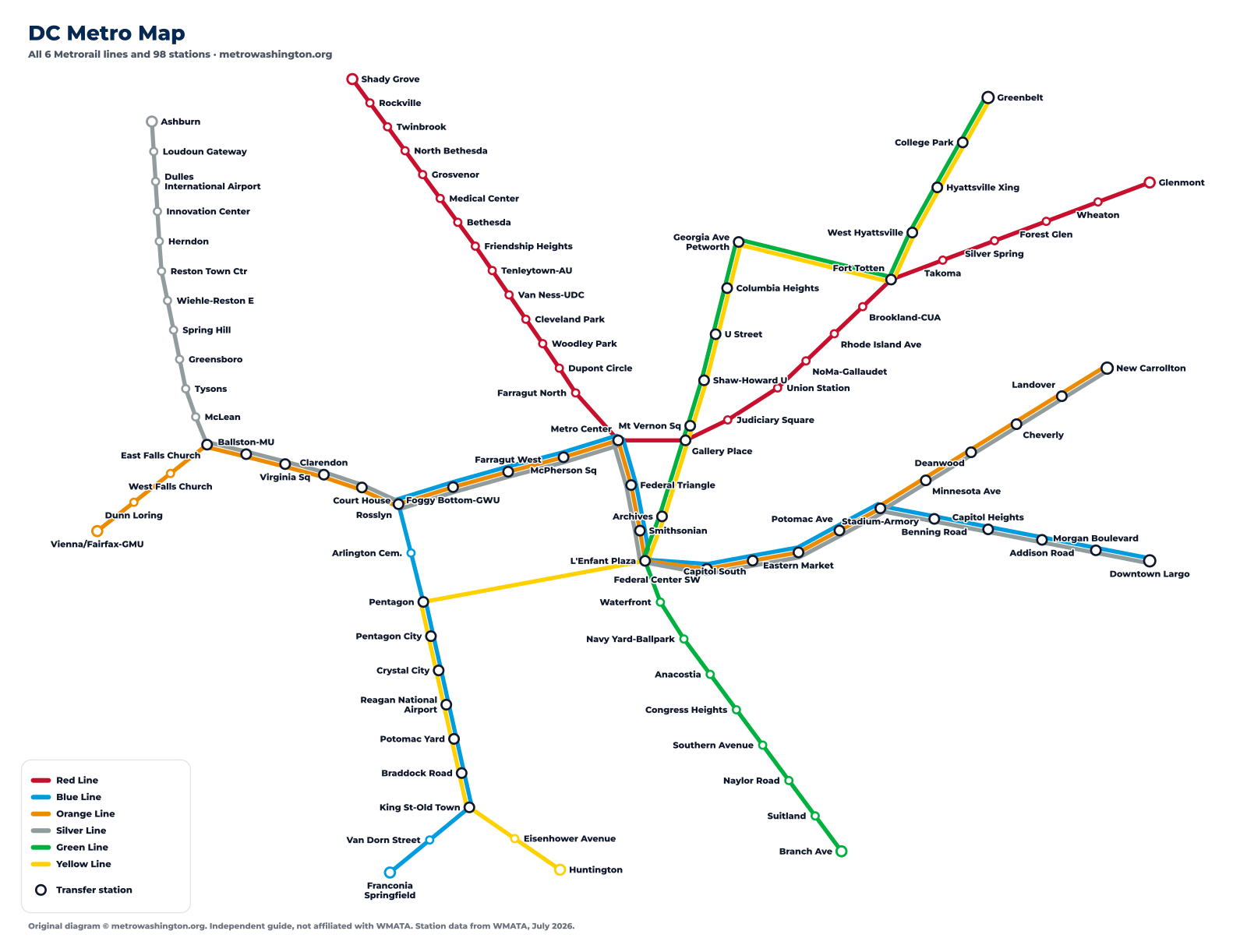
How to read the DC Metro map
The DC Metro map looks more complicated than a six-line network should, and there is a good reason for that: most of the lines do not have their own track. Once you know which stretches are shared, the map becomes much easier to read.
The downtown trunk. Blue, Orange and Silver run together on one pair of tracks all the way across the middle of the city, from Rosslyn in Virginia through Metro Center and the Mall to Stadium-Armory. Thirteen stations in a row are served by all three lines. If you are traveling within that stretch, take whichever of the three arrives first – they all stop everywhere.
The north-south pair. Green and Yellow share every station from L’Enfant Plaza north to Mt Vernon Square, and Yellow trains that continue past there run on Green Line track all the way to Greenbelt. South of L’Enfant, Green heads southeast on its own toward Branch Ave.
The Virginia riverfront. Blue and Yellow share seven stations from Pentagon south through Reagan National Airport to King St-Old Town, then split – Blue toward Franconia-Springfield, Yellow toward Huntington.
The Red Line stands alone. It is the only line that shares no track with anything else, running in a broad horseshoe from Shady Grove in the northwest, down through downtown, and back out northeast to Glenmont.
Transfer stations on the DC Metro
These are the stations where you can change between lines. Every one of them is a change inside the paid area, so you never pay a second fare to switch trains. The one exception is the Farragut Crossing, explained below.
The Farragut Crossing
Farragut North (Red Line) and Farragut West (Blue, Orange and Silver) are two separate stations about a block apart. They are not connected underground, but WMATA treats a walk between them as a transfer: exit one, walk to the other, and tap in again within 30 minutes with the same card and you are not charged a second fare. It is often faster than riding round through Metro Center.
Which stations are on more than one line?
47 of the 98 DC Metro stations are served by more than one line – an unusually high proportion, again because of all the shared track. Five lines call at L’Enfant Plaza, which makes it one of the busiest interchanges in the system.
Shady Grove – Glenmont
27 stations · about 62 min end to end
Blue LineDowntown Largo – Franconia-Springfield
28 stations · about 63 min end to end
Orange LineNew Carrollton – Vienna/Fairfax-GMU
26 stations · about 55 min end to end
Silver LineDowntown Largo – Ashburn
39 stations · about 85 min end to end
Green LineBranch Ave – Greenbelt
21 stations · about 49 min end to end
Yellow LineHuntington – Greenbelt
22 stations · about 51 min end to end
Printing the DC Metro map
The PDF above is vector artwork, so it stays sharp at any size – print it at A4 or letter size and every station name is still legible. It is also the version to keep on your phone, since it loads without a network connection once downloaded.
The map is our own drawing, not WMATA’s. WMATA’s official map is a copyrighted design and we do not reproduce it; what you see here is built from the same underlying facts – which stations exist, in what order, and where the lines meet – laid out our own way.
Frequently asked questions
Six: Red, Blue, Orange, Silver, Green and Yellow. They serve 98 stations over about 128 miles of track.
Yes – the download button on this page gives you a vector PDF that prints sharply at any size and works offline on a phone.
Because most of the DC Metro runs on shared track. Blue, Orange and Silver use one pair of tracks across downtown, Green and Yellow share the north-south route, and Blue and Yellow share the Virginia riverfront. Only the Red Line has its own track throughout.
L’Enfant Plaza, where five of the six lines call – Blue, Orange, Silver, Green and Yellow. Metro Center has four: Red, Blue, Orange and Silver.
No. This is our own diagram, drawn from WMATA’s published station data. WMATA’s official map is a copyrighted design and is not reproduced here. For the official version, see wmata.com.